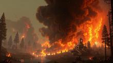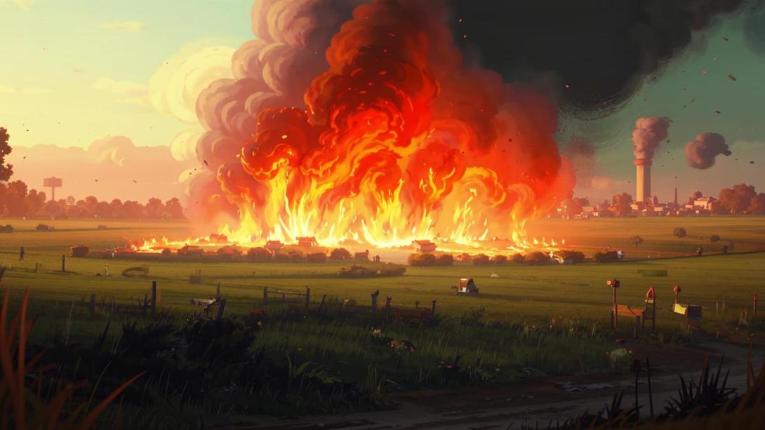
Large-scale fires that engulfed the steppe territories of the North Kazakhstan and Akmola regions in late April destroyed around 174 thousand hectares of land — an area comparable in size to the city of Almaty. Although the exact causes of the fires have yet to be determined, preliminary data suggests a high probability of human factors, exacerbated by dry weather conditions.
However, it is not only important how and why the fires started, but also where exactly they occurred and who owned the land. After all, by law, it is the owners and tenants who are obliged to carry out fire prevention measures, monitor the condition of the land, and bear responsibility for its preservation.
In early April, the media was full of news about fires in the North Kazakhstan region, where, according to some reports, four steppe fires occurred covering a total area of 35 hectares. In addition, 76 incidents of dry vegetation burning were recorded, covering an area of approximately 200 hectares.
During raids, 10 people were brought to administrative responsibility for violating fire safety rules: nine of them received warnings, and one was fined 30 thousand tenge. At that time, it was reported that since the beginning of the year, a total of 143 fires had been recorded in the region, resulting in 13 deaths, including three children, and a further 15 people were injured.
At the same time, fires were also reported in the Akmola region. On 13 April, cases of dry grass burning were recorded in Kokshetau, Stepnogorsk and the Burabay district. The total area of the fires was 16 hectares.
According to some reports, a total of 232 fires have been recorded in the Akmola region since the beginning of the year. The main cause remains the human factor: careless handling of fire and ignoring basic safety rules.
The editorial board of the FBRK decided to check how well the official reports matched the real situation. We found that the fire zone in the North Kazakhstan and Akmola regions totalled around 174 thousand hectares, encompassing dozens of plots. Our editorial team analysed over 30 plots that fell within the fire zone and identified their owners or tenants.
In most cases, these are not vacant state lands, but agricultural lands leased out — formally used for crop production or pastoral livestock farming. Among the land users are both large Partnerships with thousands of hectares on their books, and individuals with minimal public activity. Many of them acquired rights to the land in the last 5–10 years, but it is virtually impossible to verify how effectively it was used — information on operational results, crops, turnover, and participation in state programmes is either absent or extremely fragmented.
For example, Bereke Akzhar LLP, registered in the Akzhar district of the North Kazakhstan region, under the leadership of Sapargaliy Mirmarov — a company with tax payments of 31 million tenge, but with enforcement proceeding debts of 3.7 billion tenge. Its management is banned from leaving the country, and its assets and accounts are frozen. A logical question arises: how can a company with such problems manage extensive land plots?
Equally curious is the case of Alkaterek Agro LLP. The head, Baganaly Asanov, simultaneously directs another enterprise in the same region — Kok-Zhailau Agro LLP. Among the founders is Kairat Kabdushev, who has a ban on leaving the country and attachments on everything from property to bank accounts. Furthermore, the company is classified as high-risk by the tax authorities.
The situation in the Akmola region is no better. Bulaevo-Tselina LLP ceased to exist in January 2025, leaving behind millions in debt and attachments on property. Other large land users — ART-S-Batyr LLP and Sapphire Beef LLP — although still operating, have only paid 4.17 and 16.05 million tenge in taxes respectively since 2015.
Most of the lands affected by the recent fires were leased out by decision of local akimats. At the same time, almost all of these plots have restrictions listed in the cadastral information: protective and sanitary zones, water protection strips, and other elements of an environmental protection regime. In other words, these are lands for which special requirements are initially imposed. Such territories play an important role in preserving ecosystems. They protect water bodies, provide habitats for wild fauna, and curb the spread of erosion. This is why fires on such plots are particularly dangerous: the damage to biodiversity could be irreversible, and restoring such landscapes will take years, if not decades.
From a legal standpoint, tenants are responsible for the preservation of the land and its rational use. The Land Code obliges tenants to carry out agrotechnical, fire prevention, and other measures to prevent land degradation. Furthermore, the Code stipulates that land plots may be taken back from a tenant in cases of non-use or use with violations. However, in practice, control rarely leads to sanctions. In most regions, supervisory functions are formally carried out by local departments, but inspections, especially unscheduled ones, are conducted sporadically. Even more so on remote steppe plots.
This raises a legitimate question: by what criteria does the state select tenants for such plots? In practice, after the lease agreement is signed, interest in the future fate of the land seems to fade away. Control over compliance with usage conditions is formal, and there appears to be no systematic check at all to see whether the land is actually being used as intended and in accordance with environmental restrictions. As a result, a fire becomes not just an emergency, but a symptom of a deeper problem — the weakness of the institutional land management system. Until disaster strikes, the plot seems to fall off the radar of state bodies.
Also worthy of particular attention is how open land use data actually is. For example, the cadastral map does not contain data on a tenant's operational results, the existence of sub-leases, the use of subsidies, or measures taken to protect the land. And in conditions where we are talking about hundreds of thousands of hectares, this creates a zone of opacity where responsibility is difficult to pinpoint.
If mass fires like those in April do not become a reason to revise the control mechanism, the state risks not only losing significant natural resources but also perpetuating a dangerous model: land is formally transferred, used partially, and becomes vulnerable at a critical moment. This problem has not only environmental but also socio-economic dimensions: in the context of intensifying droughts, climate change, and a shortage of pastureland for livestock, every hundred hectares takes on strategic importance.
An effective solution to the problem requires not only strengthening control over the use of agricultural land but also increasing the transparency of such inspections. Society should have access to information about who the tenant of the land is, how it is being used, and what consequences follow in the event of failure to fulfil obligations regarding its protection and rational use. Currently, the accountability mechanism is mainly activated post factum, after negative consequences have occurred, if it is activated at all, which once again points to the need for systemic changes in the sphere of land resource management.
The inconsistency in the application of environmental sanctions by various supervisory bodies deserves special attention. While oil-producing companies, industrial enterprises, and producers of mineral fertilisers (such as large phosphate plants) are systematically subjected to strict inspections and significant fines for environmental violations, land users whose actions or inaction lead to environmental damage on no smaller a scale often remain off the radar of regulatory structures. Both private landowners and environmental supervisory bodies effectively turn a blind eye to the problem, although according to the logic of environmental legislation, fines amounting to billions of tenge should be imposed for such consequences.
The selective application of fines and sanctions creates a distorted incentive system: damage inflicted over a large area and in a dispersed form is often perceived as less significant than localised incidents, such as industrial emissions. Meanwhile, the cumulative impact on the ecosystem can be equally serious. The absence of uniform standards for assessing environmental damage and consistent response undermines the effectiveness of environmental policy and contributes to the further destruction of vulnerable natural territories.